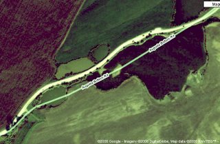
 In a recent post, I whined about the condition of the Augusta Bottom Road. Above is the Google Map of the worst section of the road. I played around with the color to make the water holes stand out.
You can see the vehicle traffic on what pretends to be the "road" -- the dark objects on the wider white ribbon.
Google Maps has drawn the "map" of the road to the right of the actual road -- it drew the road where it used to be before the Great Flood of 1993. As you can see, there are now two sizeable bodies of water where the road was, the larger is the darker area center right. The smaller is the green oval to the left. These are called scour holes, and are often created during a flood when a levees fails.
So, thirteen years later, nobody has fixed this mess.

1 comment:
Probably no one has complained, at least to the people in charge of road repair. In our town, the city doesn't repair anything unless someone calls and makes an official complaint. No routine maintenance. I called the city administrator's office to ask why our road wasn't fixed and he said "no one has asked us to fix it", so there you go.
-----------------------------------
some cities pride themselves on having bad streets, something that I have never understood -- the best known is Pitgtsburgh
Post a Comment