
There is a new a park on the
Missouri side where the
Missouri and
Mississippi Rivers come together -- the
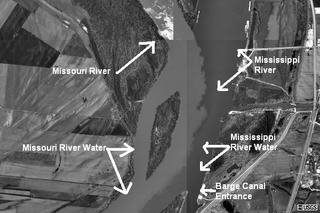
Edward "Ted" and Pat Jones-Confluence Point State Park (and, yes, they put all of that on all the signs). As you can see in the two photographs above, however, the rivers might conflux but they do not mingle and mix very much. The brownish water from the
Big Muddy Missouri stays to the west, while the clearer water of the
Mississippi stays to the east. The flows of the two rivers do not actually fully intermingle until they are well past
St. Louis. On their way to that point, what the two rivers really want to do is form islands to separate the two flows. The Corp of Engineers takes a dim of this, however, and tries to force the water back into a single main channel. The most famous of the islands was
Bloody Island in middle of the river between
St. Louis and what is now
East St. Louis. Dueling was illegal in
Missouri so all interested parties would row over to
Bloody Island and shoot away. When the main flow of the river decided it would rather be between the island and the
Illinois shore, and leave the
St. Louis shore, none other that Major Robert E. Lee was sent to close off the east channel and force the river back to the
Missouri side of the island. The I-55, I-64, I-70, US 40, IL 3 ramps to the
Poplar Street Bridge and a riverboat casino occupy the site of the former island.
MSN/TerraServer Map <== Keep clicking SOUTH and you can easily follow the darker appearing water from the Upper Mississippi all the way to the Arch. [If the link will not work, use Longitude -90.15 and Latitude 38.82.]

 There is a new a park on the
No comments:
Post a Comment